
Pierre L’Enfant was a jerk.
Sure, the street grid he set out for DC has some truly fantastic public spaces and grand boulevards, but all the monumental axes and diagonal streets really slice up the available space, leaving lots of unusual triangles and pocket parks. Pretty much all of those spaces within the central part of DC are governed by the National Park Service, who controls 637 distinct parcels for recreation and presumably the eventual installation of monuments to increasingly benign national figures and historical events. In total, the NPS possesses some 6,700 acres out of the 39,300 acres (land only) of the District. That’s about 17% of the District, and when you add in other federal land it brings the total up to about 23%... which is still lower than 12 other states. (Nevada is 84% federal land!)
Anyway, several of these spaces are circular. A few are technically roundabouts, but the vast majority of them have some form of signalization and are therefore classified as traffic circles. All in all, there are 34 circles in the District of Columbia, of which 31 are named after noteworthy people. However, recent developments at one intersection have raised that total up to 35, as we’ll see in a moment. But first, some Traffic Circle Trivia!
The Smallest Circle
Anna J. Cooper Circle is the smallest named circle. There are several smaller ones, but they’re little more than mini-roundabouts with some grass in the middle.
 |
| Cooper Circle has benches and trees! |
The largest circle is Dupont Circle, for which the neighborhood I live in is named. The landscaped part in the center is a whopping 360’ across and is home to a fountain, a half dozen chessboards, 1200 linear feet of benches, and a small population of homeless people who seem to enjoy shouting at passersby on Friday and Saturday nights and at each other all of the other nights of the week.
 |
| Massachusetts Avenue is busy enough that it gets express lanes (blue) around the inside of the circle, but Connecticut Avenue traffic is even heavier, so it gets a tunnel under the circle (green). |
The Least Circular Circle
Many traffic circles have been modified over the years to better handle the ever-increasing volumes of commuter traffic present along DC’s roadways. Dupont had a tunnel and express lanes installed, but at least it’s still a circle. Not all “circles” have been so lucky – many have had the primary road punched through the center, and in some cases all that remains of the circle are some glorified frontage roads, much like the ones found at Wesley Circle near American University.

DC has a thing for perimeter roadways. Nearly all of its border with Maryland is marked by roads with uncreative names like “Southern Avenue,” and like many other major intersections in the District some intersections along these roads have circles as well. Most of them straddle the border, but Pinehurst Circle in Chevy Chase doesn’t quite line up properly.

New York Avenue carries US 50 from downtown out towards Annapolis. There used to be a traffic circle at its intersection with Florida Avenue, but eventually traffic volumes got so high along New York Ave (currently about 60,000 vehicles per day) that the District decided to take out the circle and put in a traffic light that favored commuter traffic. However, the redevelopment of several commercial corridors along Florida Avenue – U Street to the north and H Street to the south – has meant that a the side street volumes are swiftly approaching the limit of what the signal can handle, and there simply isn’t room for more traffic lanes.
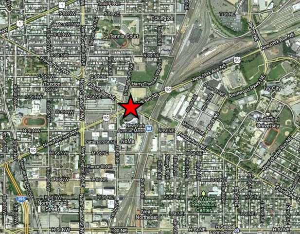 |
| The intersection is kind of a big deal. |
Another issue at this intersection is a common one in DC – everything’s simply too close together. L’Enfant’s diagonal streets certainly make trips shorter, but they also confound the street grid. At the intersection of New York and Florida, there were 5 intersections within a 50-yard radius, which made coordination of the signals somewhat tricky.
So after a long period of study, what the District of Columbia Department of Transportation (DDOT to you and me… even their logo is just “d.”) decided to do is to create a virtual traffic circle using the existing street network. First, they kept traffic along New York Avenue as it was, except they prohibited left turns from the main roadway. Next, they converted a block each of Florida Avenue, 1st Street, and O Street to one-way operations in order to create a “traffic triangle” with a Wendy's in the middle.
 |
| Image from Flickr user tbridge |
The punchline of this situation is that while most traffic circles in DC are named after locations, politicians, and generals, this one has been given a quite relevant and, in my opinion, humorous name. Because of the presence of a Wendy's on the island in the middle, people have started calling this one "Dave Thomas Circle" after the founder of Wendy's. I guess he counts as a famous American.
Now, the operations of the circle are pretty cool too. If you want to travel southbound on Florida avenue, you have to turn right on 1st then left on O to travel around the legs of the triangle. If you’re heading east on New York and you want to turn left onto Florida, you actually have to turn right onto O before you can turn left onto Florida and shoot across the hypotenuse.
 |
| Click for a bigger version. Please, I spent a lot of time on this. |
- Eastbound + Westbound New York
- Northbound Florida + 1st
- Southbound 1st + Eastbound O
instead of the 5 phases that all of the intersections were using before:
- Eastbound New York + lefts
- Eastbound + Westbound New York
- Westbound New York + lefts
- Southbound Florida + 1st
- Northbound Florida + 1st
 |
| The cycle length is still 100 seconds, but the extra 8 seconds of lost time gained every cycle (3 yellow + 1 all red for both trimmed phases) adds up to a considerable bonus over the course of a day. |
Next time, in Part II of my series on DC Curiosities, we’ll learn about the District of Columbia’s official dinosaur just in time for CAPITALSAURUS DAY!
And yes, with the possible exception of me blowing off another deadline and missing Capitalsaurus Day, none of that previous sentence was made up.