

My original goal for the day in Manhattan was to try to leave by nightfall so I could be back to Richmond before midnight. But after looking at a map and making a list of all the places I wanted to see, it became obvious that my plan wasn't going to work out. Plus, when I found out that the MTA had discontinued the 24 Hour Unlimited transit pass I realized that I was going to have to do quite a bit of walking to make it all work out without paying more than I cared to on subway fare.
With nothing else to plan, I strapped on my boots and headed out the door of my uncle's walk-up studio apartment for another whirlwind tour of a major city in the style of my summer Europe trip.
Union Square
First, I had to pick up some cash. My trip to Nathan's the previous day had left me with $3, and that wasn't going to work. So I walked up to the nearest Wells Fargo branch, which happened to be a mile and a half away in Union Square. Fortunately for me, Union Square is far enough north that you can start to see some of the skyscrapers of Midtown, giving me a hint of what I'd find the rest of the day.

Grand Central! Grand Central! Grand Central!
I hopped on a number 5 express train, and before I knew it I was at a stop where I just had to get off. For a transit nerd like myself, Grand Central Station is like a great cathedral. The edifice is large and prominent, and because of its place standing in the middle of Park Avenue it is visible from blocks and blocks away.
 |
| The facade is so wide I had to make a panorama. |
But that's part of the beauty of Grand Central - everything is enormous. It's all about the sense of scale, from the towering windows to the high, broad arched ceiling, everything is meant to bring a sense of openness to the traveler that frankly is lacking from modern transit facilities. Just look at what happened to Penn Station. However, unlike its cross town sister, Grand Central has handled the decline of intercity rail well, becoming a hub for subway traffic and commuter rail - and actually doing a pretty good job of it, too. Commuters crisscross the floor of the main hall at all hours of the day, and really it's just a fantastic place to sit back and watch the world go by.

But there was no time to loiter around - I started out on East 2nd Street, as I exited Grand Central I found myself only at 42nd. With plenty of traveling left to do, I set off west towards the center of the island. A long block later (Manhattan's blocks are rectangular, with the east-west direction about four times longer than the north-south one, at 1/5 mile versus 1/20 mile), I found myself crossing Fifth Avenue, and snapped this picture facing north. The road is perfectly straight and almost completely flat until it dumps into the East River at 143rd Street, 101 blocks to the north (that's 5 miles for those of you playing along at home), interrupted only by a couple of rotary intersections and a park with a swimming pool up in Harlem.
 |
| It really is a like being in an urban canyon. |
The Avenue of the Americas
I continued east, eventually reaching Rockefeller Plaza. Just like with all good touristy attractions, everything there was tremendously expensive, so I passed on doing iconic things like visiting the skating rink or Top of the Rock. I did, however, get to see Lutz from 30 Rock standing around outside the front doors in a big cordoned-off area, so I'll have to keep an eye out to see if that scene pops up in a future show.


On my way out of Rockefeller Plaza, I swung by Radio City Music Hall before heading north down Sixth Avenue. Eventually, I reached 56th Street - Central Park South, complete with fancy hotels and things - and entered Central Park.
Central Park
Compared to the asphalt flatness of Manhattan, Central Park is quite a welcome shock. Trees abound, wildlife (albeit a limited selection) bounds around, and rock outcroppings rise up out of the earth as the many walking paths swoop around from ballfield to lake to meadow. As you get further into the park, traffic noise dwindles and a sense of tranquility envelops you, only broken by the occasional oddly echoy outdoor skating rink or the occasional sunken traverse roads that cross the park every ten blocks or so.
 |
| Not only is the view from this lake awesome, it also brings the number of places I've visited in Where the Hell is Matt? up to six. |
I continued north through the park passing several noteworthy landmarks with remarkably nondescript names, like The Mall and The Lake. The best part of being in the park is when you get to one of the many big open spaces and you get to look out over a serene pond or leafy trees... only to see an impressive line of tall buildings off in the distance. It's a truly fantastic effect to look at.
Eventually, I got up to the Central Park Reservoir, which continues the effect to an even greater degree because of the sheer expanse of the pond itself - it covers 106 acres and holds over a million gallons of water - and the resulting fact that you can see such a large area of Manhattan from its shores.
 |
| They don't even use the reservoir for drinking water anymore. |
The Guggenheim
 |
| The parking situation and traffic lights really aren't set up to let you photograph the museum. |
I finally reached my turn when I got to 90th Street in order to go and see the Guggenheim Museum. Even though I'd seen it countless times in books, I figured that as long as I'd traveled 90 streets north of my uncle's apartment, I might as well stop to see some of the Wright stuff.
Even though the museum is crazy expensive - like everything touristy - they have no restrictions about coming in and visiting the gift shop. Luckily enough for me, the gift shop is right off of the atrium... which was really all I'd wanted to see anyway.

By this point, I was beginning to realize just how silly my plan to see everything in Manhattan really was. It was practically noon, I'd agreed to meet my uncle for lunch, and I was about 65 blocks away from his work. So naturally I went to see the United Nations.
The UN
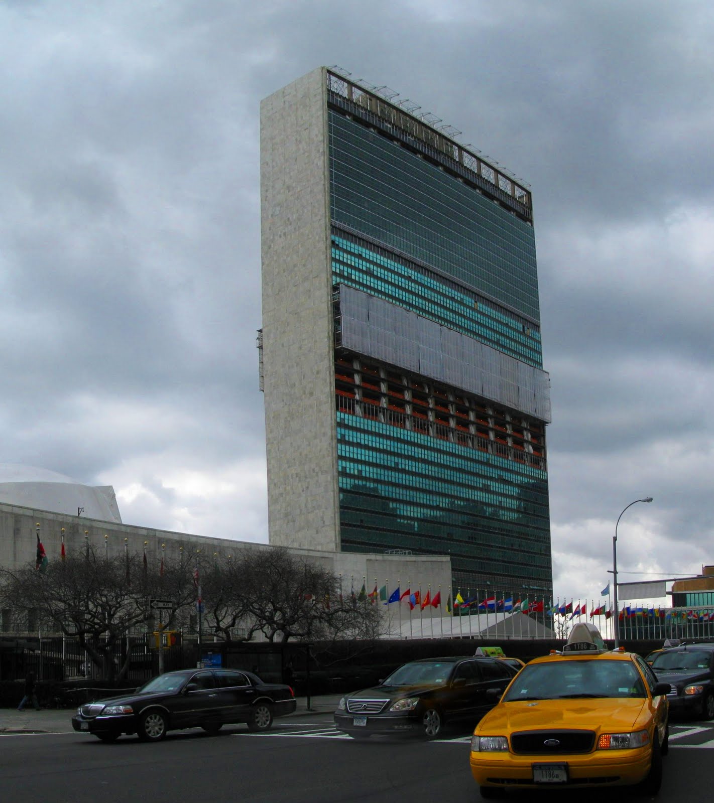
This required hopping on the subway again, riding back to Grand Central (Grand Central? Oh boy!) and then making my way 4 long blocks east to the appropriately-named East River. Unfortunately by this point it was really cloudy and the lighting conditions were bad and the building was too wide to photograph from the island side of the building and plus it was undergoing renovations anyway because apparently diplomats don't like windows that leak when it rains... so this is the only halfway decent picture I got.
And then by this point it was 12:45 and I hadn't even bothered to call my uncle yet. Oops. So after setting a plan (I'd meet him at his work on E 25th), I began consulting the bus and subway maps and timetables to pick the quickest mode to get there. The conclusion? Unless I really wanted to ride a bus (or to test out Bus Rapid Transit) it would just be quicker to walk the 20 blocks.
It was a pretty good decision, I think, except for the really frustrating signal timing. The light would turn green, you'd start heading south, and right before you got to the next cross street the light would turn red again. It just so happens that at 4 mph, it takes 45 seconds to walk 1/20 of a mile... and there was 40 seconds of green time in that direction.
Madison Square Park, Hold the Gardens
 |
| So slim! So sexy! |
Anyway, for lunch we had some pretty fantastic Indian cuisine, but before long it was time to set off again on foot. My uncle's office is near Madison Square Park (which is really nowhere close to the present-day Madison Square Garden), which is bounded on one corner by the intersection of 23rd Street, Fifth Avenue, and Broadway - the home of one of my favorite structures, the Flatiron Building.
Built in 1902, the Flatiron was one of the tallest office buildings in the world when completed, and it was the first true skyscraper in New York to be constructed with a steel frame. However, the thing that does it for me is the shape. Set on a curious triangular block, the building's longest side is only 190', the offices at the point are only six feet wide. It's like a wedge driving northwards towards Midtown, carving Broadway out of Fifth Avenue.
Another neat thing about Broadway at Madison Square is that the city has decided to cut down on traffic on Broadway and improve pedestrian safety by entirely removing cars from several sections of Broadway. In fact, in the picture above, I'm actually standing in the middle of Broadway, except planters and tables have been added to severely cut down through traffic by decreasing capacity. Although this sounds like a bad thing, it actually improves flow by reducing the volume of traffic crossing Fifth and reducing conflict between vehicles and pedestrians. A few bike lanes still traverse this section of the square, but large swaths of roadway are now available for seating and recreation.
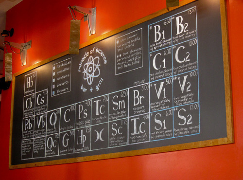
Miracle on 34th Street
After admiring the innovative traffic developments, I followed the lead of the Flatiron Building and headed north. A short hop on the N train put me squarely in the heart of Midtown in Herald Square at 34th Street and Sixth Avenue. This sight greeted me as I climbed out of the station:

That's something interesting to point out: you have to use stairs everywhere you go in Manhattan. For someone whose subway experiences are mostly limited to the Washington Metro, the lack of escalators in other cities' transit systems is most curious. However, it makes sense considering these older systems like New York, London, and Boston were built during a time period where the government could really tear up a street to put in a subway line using cut-and-cover methods. Subways built in this way are usually a lot shallower, and often it is only 30 or 40 steps to the surface. Nowadays, citizens are more involved in the construction of new transit systems through federally-mandated citizen comment periods, and so the Metro - designed during Johnson's Great Society programs of the late 1960s - was built deeper underground using submerged tunnel boring methods, hence the escalators.
However, the real reason why I stopped at 34th Street wasn't to visit the Empire State (I did that when I was six), it was to visit 34th's other famous occupant, Macy's.
 |
| You can see more of the pedestrian conversion in front of Macy's - I'm standing in the middle of Broadway here. |
 |
| I'm nerding out right here. |
However, I wasn't here to shop - I was here to sightsee. I had just recently completed my master's thesis work on pedestrian flow on escalators, and I wanted to see something I had only ever read about: wooden escalators. All four escalators between the main floor and the basement inside of Macy's are the original wooden escalators that were installed in 1927.
Get With the Times Square
From Herald Square I continued north along Broadway. As the block numbers increased, so did the showiness of the storefronts and the audacity of the advertisements. This could mean only one thing: Times Square approaches.

Times Square was crazy busy. Even with the new street enhancements like wider sidewalks, bike lanes, and the extra space that resulted from closing Broadway for five blocks, pedestrians absolutely covered every inch of sidewalk. People piled up at cross streets waiting for traffic to clear, and when the light finally turned green two walls of people twenty wide would surge towards each other like a bizarre game of Red Rover.

As I passed through Times Square, I popped down a couple of sidestreets and into a couple of stores just to see what all the craziness was all about. I saw the front of that ill-fated Spider Man musical, and I even got a chance to pop into the flagship Toys-backwards-R-Us store. They had legos!
However, the real amazing thing about Times Square is the billboards. There are all kinds of spastic electronic displays, ranging from tasteful landscape scenes in car commercials with lifesize cars hanging from the sides of buildings to garish seizure-inducing flashing monstrosities. It really is absolutely mad what these people come up with. Perhaps my favorite one was the interactive billboard for some beauty product. The board was hooked up to a camera pointed at the square, and every few minutes something funny would happen to the people down on the street displayed in the live feed, like random people catching on "fire" or the street turning into a whirlpool and everybody getting sucked away or something. But the billboard has a more notable feature, and that because it is effectively a giant mirror it is the only picture of me that I took during the entire six day trip. You can see me in the red jacket (it was kind of cold) on the blue background of the street (blue means "pedestrian zone").
 |
| Watch out Peter! That giant digital lady is going to smush you! |
 |
| It tries so hard! It doesn't even know it's been replaced! |
Another cool feature in Times Square was the visitor's center that opened last year an an old 20s-era theater. Granted, it's mostly an excuse to sell tickets to Broadway shows, but they do have a couple of cool exhibits like highlights from famous Broadway shows playing on a loop on a large screen in the old proscenium arch or historic (and g-rated) peep-show booths from the seedier days of Times Square. My favorite part was the big Waterford Crystal Ball from New Year's Eve 2007 (the 100th anniversary of the ball drop), which went through its usual color show and counted down to midnight every 15 minutes like it was still the star of the show.
North on Broadway
Continuing north, still by foot, I reached the Ed Sullivan Theater (where they film The Late Show with David Letterman), Columbus Circle (not that picture friendly), and finally Lincoln Center all the way up at 65th Street. The plays there were really expensive, but I was more visiting because of its featured role in films like The (original) Producers and Ghostbusters.
 |
| Did you see Black Swan? That was here. |
Financial District

I then boarded a train again and dived back down south to catch a few more sights before the evening rush began. I stopped by the new construction on One World Trade Center, wound my way around the waterfront behind the World Financial Center, and checked out some of the winding streets that characterize the old-town feel of the financial district in general.
On my way back towards the center of the island after stopping along the Hudson, I couldn't resist poking my head into the WTC PATH Station ("Port Authority Trans-Hudson", the commuter rail that goes to New Jersey), mainly because it is home to one of the highest-capacity escalator banks in the world. During peak rush periods, six of the eight escalators in "PATH Hill" are switched to the same direction, allowing people to enter the station at the rate of 38,000 people per hour. Granted, there are only 40,000 people that use the station per day (and that counts both directions), but given how quickly the financial district in Richmond clears out I get the idea that most of that traffic happens in a pretty short window.
In fact, there's a 35-second scene in the fantastic documentary Koyaanisqatsi that features the pre-9/11 WTC PATH station and its escalators showing just how busy the escalator bank can be as traffic flow swells and ebbs as trains arrive.
 |
| Would you believe this is only a temporary station until they finish the real one in 2014? |

On my way out of the financial district I popped down Wall Street just as 5:00 struck, and all of the sudden it seemed like EVERY PERSON IN THE WORLD was rushing towards me. I retreated out of the way up some steps, and in what could only have been a couple of minutes the crowd completely vanished and the place became practically a dead zone. As I walked back out onto the street, I found out that the stairs that had offered me shelter were the iconic Federal Hall, which served as the first capitol building in the United States.

After a bit of searching, I found the New York Stock Exchange practically across the street. I hadn't noticed it there because I was expecting it to be sporting the oversized American flag it seems to have in most pictures these days instead of a large advertisement featuring Tyra Banks, which kind of ruined the stuffy capitalist atmosphere of the place.
Civic Center
Given the late hour, I started to make my way back towards my uncle's apartment. I walked north, eventually reaching the Civic Center, home to New York City Hall and the far more imposing Manhattan Municipal Building.
 |
| It's big, AND it was featured in Ghostbusters! |
Right across the way is the base of the Brooklyn Bridge. Because of how high above the water it is, the base of the bridge is actually over 1/3 of a mile away from the river, which make for an interesting set of loopy roadways in order to connect the bridge to all the important streets it bypassed because of the elevation difference. In fact, from where I'm standing in the picture below I'd only have to walk one block to the other side of city hall before I'd be closer to the Hudson than the East River. Manhattan really is a remarkably compact place.

 |
| Foley Square is home to the New York County Supreme Court... from Law & Order! |
I only had to go one block further north into Foley Square before I could catch one of the green line trains north to a station near my uncle's apartment. It was still about a mile of walking between that station and his place, but along the way I got to cross Bowery and Houston, and across the intersection there was a fantastic view of the Empire State Building some two miles to the north.
The End of the Tour... or is it?
And so as I climbed the four stories up to my uncle's apartment, it became pretty obvious that I was in no state to drive a further six hours to Richmond. And so as soon as he offered to let me stay another night, I readily accepted and we hatched a plan to go see a few more sights.
First, we hailed a cab (a cab!) on the corner outside his place and headed west down Houston towards Chelsea and the Meatpacking District to see a place I'd only ever read about, the High Line!
The High Line
Most cities these days have some kind of linear park - either a walking trail, or a bike path on a converted railroad bed, or something that can be used for exercise or recreation. However, a dense borough like Manhattan doesn't really have the kind of space to put in one of these... at least not ordinarily. However, a unique opportunity existed in this part of town. The historic meatpacking industry needed a lot of freight shipments to bring in raw meat and process it into usable products, and much of this was done by rail. As street traffic increased, the railroads eventually agreed to fund a tremendously expensive elevated rail trestle to bypass over 100 at-grade rail crossings and expedite shipping. Over the years, the decline of the meatpacking industry in Manhattan proper meant that rail shipments effectively ceased, and the trestle fell into disrepair and became overgrown with vegetation and graffiti. Generally, it was a nuisance and an eyesore, and property owners around the trestle lobbied for its demolition.
However, in the last five years, the city and private investors have scraped together funding to redevelop the trestle from its original function as the carrier of several rail tracks into a linear park. If you think about it, a linear park really is the perfect use for an old trestle - it's physically isolated from the street network so it is safer for its users while also providing a continuous ribbon of pathway. It's also quieter and because of the controlled access points at the occasional stairwell or elevator, it is easier to lock up at night to discourage misuse.
 |
| They selected vegetation to mimic what grew naturally during its abandoned phase. |

The High Line has become very popular in the neighborhood. It gives its users an escape from the harshness of their formerly industrial neighborhood, with tasteful landscaping and benches of varying architectural themes. In fact, many of the groups who called for its demolition only a few years ago are now enjoying higher property values as a result of having a park right outside their door. Heck, the trestle even cuts through buildings in a few places where the trains used to be able to unload, so it is great that they were able to keep those features.

There are also a few more quirky features, like this ampitheater-style seating area with glass windows that looks out north along Tenth Avenue (right). I could sit there and watch the traffic go by all day. It kind of makes me wonder what it would look like if Tenth Avenue were to freeze out.
The High Line isn't anywhere close to finished yet - only about 1/3 of it is open to the public - so after only 9 blocks (about half a mile) we descended down and went to dinner. Let me tell you, food is EXPENSIVE in Manhattan.
SoHo, Little Italy, and Chinatown
On the way back, we were again faced with a mode choice dilemma. My uncle insists that there is no good way to travel east-west across Manhattan (except for maybe buses, and we didn't have a bus schedule), so we decided to walk back to his place. Turned out to be a good choice because it allowed us to wander through some of Manhattan's older residential neighborhoods.
Unlike most of northern Manhattan, this region's streets are not at the standard 29 degree tilt, and in fact a few of them even have CURVES, what a crazy concept. We zigzagged our way southeast through NYU and eventually came upon Washington Square Park, home to the appropriately named Washington Square Arch, which has been featured in more moves than I care to name.
I snapped this photo of the arch and Fifth Avenue stretching out north beyond, and it was only after I got home to Richmond and was sorting through my photos that I realized that the Empire State Building had snuck into the background and photobombed me.
 |
| The Empire State is ALWAYS WATCHING YOU. |
Gmap-Pedometer.com
It certainly felt like I'd walked a long way, but without a pedometer to track my steps I really couldn't be sure how far I'd traveled. Fortunately, there are many websites like the Gmap Pedometer to let you figure that kind of thing out in a much easier way than adding a bunch of destinations into Google Maps. Plus, it lets you use terrain data to create profile views of your route as well... although in Manhattan that view would be quite boring.
According to my calculations, all in all I walked 22.3 miles while in Manhattan. Ouch. 22 miles on dirt is uncomfortable, but pavement is much less forgiving. I was glad to be sitting down for most of the next day.
Anyway, I took the resulting maps and stitched them together into the large map below, and added in labels highlighting the various landmarks I visited on my travels. Walking is shown in the red lines, and other modes of transport are shown in dashed lines and labeled with the mode of travel or train number. My uncle's apartment is near the bottom in the center, and trips are numbered in order of when I took them. The numbers in the red bubbles are mileage for that particular leg of the trip.
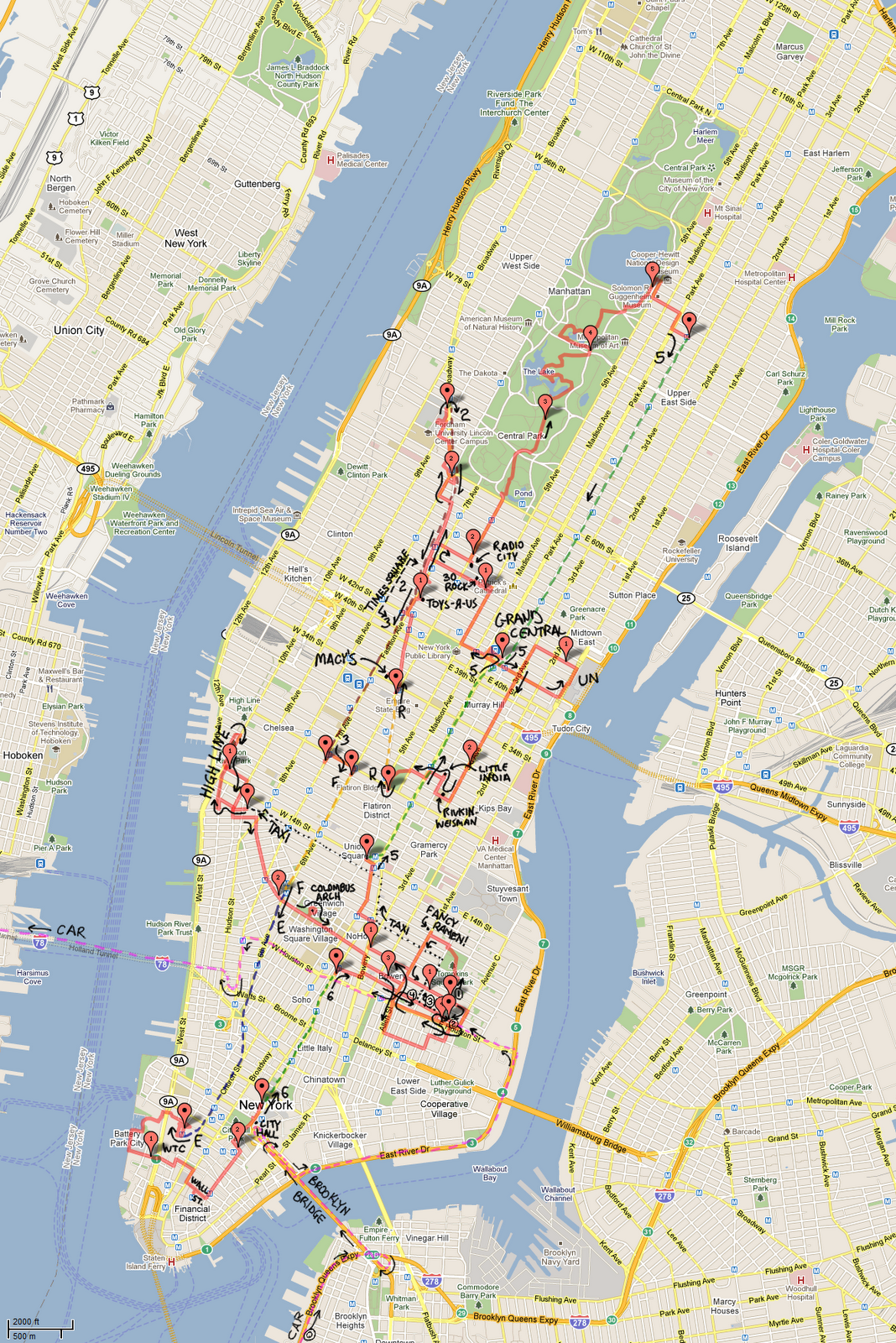 |
| I would not recommend this agenda to visitors. Click to enhance. |
In our next (and hopefully final) installment of the Boston Trip, Peter drives the last six hours to Richmond. On the way, he gets carried away discussing quite a number of controversial transportation topics, but we'll cut that stuff out. That guy is a real windbag, as you've clearly just seen.


